El Niño Could Ignite the 2026 Eastern Pacific Hurricane Season, Raising Risk of Rapid Intensification
Experts warn a developing El Niño could fuel a significantly more active Eastern Pacific 2026 hurricane season, producing warmer ocean waters, reduced shear, more intense storms and a greater risk of rapid intensification — while suppressing Atlantic activity.
Key takeaways
- El Niño could boost Eastern Pacific storms: warmer ocean heat content and altered winds increase the chance of stronger, more frequent systems (Fox Weather).
- Odds and intensity: NOAA and model guidance put the chance of El Niño forming in May–July 2026 at about 61%, with ~25% odds it could grow into a “super El Niño” by fall (Time).
- Push and pull: El Niño typically suppresses the Atlantic while energizing the Eastern Pacific, shifting coastal and inland risks on both sides of the Americas (Fox Weather; video background).
How El Niño affects the Eastern Pacific
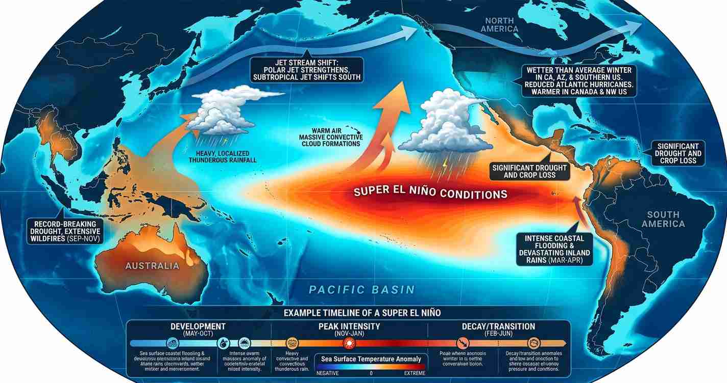
El Niño is a periodic warming of the central and eastern equatorial Pacific Ocean. When it forms, sea surface temperatures rise across the central and eastern Pacific and feed more moisture and energy into developing storms. Forecasters note ocean temperatures in parts of the Pacific are already 1–3°C above average as the event builds (Fox Weather).
At the same time, El Niño alters upper-level wind patterns. In the tropical Atlantic and Gulf of Mexico, it tends to strengthen upper-level winds and increase vertical wind shear, which suppresses Atlantic storms. Over portions of the Eastern Pacific, however, local shear can be lower and convection stronger — permitting faster organization and strengthening of tropical systems (explanatory video; related overview).
Why El Niño can “ignite” the season
Three linked factors make the Eastern Pacific more dangerous in El Niño years:
- Warm ocean heat content: Deeper layers of warm water mean storms have more fuel and can sustain intensity longer (Fox Weather).
- Lower local wind shear: Reduced shear in parts of the Eastern Pacific helps storms keep their structure and intensify — a contrast with the Atlantic (explanatory video).
- Higher chance of rapid intensification (RI): Warm, deep water enables fast strengthening. Forecasters point to Hurricane Otis (2023) as a stark example of how quickly a Pacific storm can intensify when conditions are ripe (Fox Weather).
“Rapid intensification can leave communities with little time to prepare.” — forecasters’ warning about warm, deep waters fueling RI events.
Timing matters for 2026
The timing of El Niño’s development will shape the seasonal pattern. If El Niño forms early — before mid-summer — it can establish a stronger-than-average season across much of the Eastern Pacific basin. If it forms later, Atlantic or Gulf storms may have a longer window before Pacific conditions fully shift (video explanation).
Forecast outlook
NOAA and ensemble model guidance, as summarized by analysts, place the chance of El Niño developing during May–July 2026 at roughly 61%, with about a 25% chance it could become a strong or “super” El Niño by fall (Time). A super El Niño would push Eastern Pacific sea surface temperatures far above normal late in the season — in some forecasts, 2–3°C above average in November and December — amplifying storm intensity and frequency (Time).
Historical trends
On average the Eastern Pacific basin sees about 15 named storms, eight hurricanes, and four major hurricanes per season. During El Niño years those averages have trended higher — roughly 17 named storms, nine hurricanes, and five major hurricanes — indicating a consistent uptick in activity when El Niño conditions take hold (Fox Weather).
Contrast with the Atlantic basin
El Niño’s push-and-pull effect is clear: stronger upper-level winds and increased shear across the tropical Atlantic and Gulf tend to suppress storm formation there, while the Eastern Pacific gains fuel from warmer waters. Current tropical Atlantic sea surface temperatures are near or below average, pointing toward a potentially quieter Atlantic season in 2026 even as the Eastern Pacific becomes busier (Fox Weather; video background).
Rapid intensification: a key danger
Rapid intensification (RI) — a dramatic increase in wind speed over a short period — is particularly hazardous because it shortens preparation time. Deep warm water under an El Niño raises the odds of RI events. The sudden strengthening of Hurricane Otis in 2023 remains a cautionary example of how quickly a Pacific storm can escalate, surprising forecasters and residents (Fox Weather).
Eastern Pacific season timing and watch dates
The Eastern Pacific hurricane season runs from May 15 through November 30, and the first named storm typically forms near June 10. With El Niño likely to form in late spring or summer, early- to mid-season activity in 2026 could already reflect El Niño influences if the event materializes on schedule (Fox Weather).
Implications for the Imperial Valley, California
El Niño-driven changes in Pacific storminess carry local consequences for the Imperial Valley — economically, politically and socially. Below are key impacts and practical recommendations for residents, farmers and officials.
Economic impact
- Agriculture: The Imperial Valley depends on predictable weather and irrigation. Strong Pacific storms can bring beneficial rain but also destructive floods that damage crops, irrigation systems and harvests. Farmers should review insurance and emergency plans (Fox Weather).
- Infrastructure and trade: Roads, canals and border crossings may be disrupted by heavy rain or flash flooding, delaying produce movement and raising costs for growers and shippers.
Political consequences
- Local emergency planning: County and city leaders may face pressure to update emergency plans, shelters and funding priorities for drainage and levee repairs.
- Cross-jurisdiction coordination: Proximity to Mexico makes state, county and international coordination essential for preparedness and resource sharing.
Social effects
- Vulnerable communities: Many residents work in agriculture and live in lower-income households; rapid weather shifts can hit these groups hardest through lost wages, damaged housing and health risks.
- Public health: Standing water and flood damage can increase disease risk and strain medical access; clinics and hospitals should plan for surges.
Cultural relevance
Storm-driven disruptions could affect community networks, seasonal festivals and harvest gatherings in a region where cultural life is tightly linked to the agricultural calendar.
Practical applications — what locals should do now
- Review family emergency plans: Know evacuation routes and have a disaster kit ready.
- Farmers: Check crop insurance, irrigation protections and drainage plans with county agricultural extension services.
- Local officials: Audit critical infrastructure — canals, pumps, levees and roads — and update surge capacity plans.
- Residents: Sign up for local alerts and monitor county emergency channels for flood warnings.
- Health services and shelters: Prepare for surges and ensure language-accessible outreach for vulnerable populations.
Sources and further reading
- Fox Weather: “El Niño could boost hurricane activity in the Eastern Pacific in 2026”
- Time: “Super El Niño 2026 — What to know”
- Background video: El Niño impacts overview
- Explanatory video: how El Niño changes wind and shear
- Related overview: Pacific storm dynamics
Reporting by Times Media Service